


Gr34 le Conquet Aber Ildulte

taguette
User
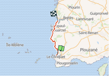

Length
18.8 km

Max alt
42 m

Uphill gradient
243 m
Km-Effort
22 km

Min alt
0 m

Downhill gradient
263 m
Boucle
No
Creation date :
2025-04-28 07:29:23.573
Updated on :
2025-04-28 13:33:38.807
6h03
Difficulty : Very difficult

FREE GPS app for hiking
 SityTrail
IGN / Geographical institutes
SityTrail Plus
The world is yours!
About
Trail Walking of 18.8 km to be discovered at Brittany, Finistère, Le Conquet. This trail is proposed by taguette.
Positioning
Country:
France
Region :
Brittany
Department/Province :
Finistère
Municipality :
Le Conquet
Location:
Unknown
Start:(Dec)
Start:(UTM)
369182 ; 5358432 (30U) N.
Comments